
Search
Interfaces
n
n
nKeyword
| Now, we will cover the
various ways in which users are allowed to perform searches in spatial and
temporal DL. |
|
| Keywords: |
|
| This is a very fundamental
search method that is present also in traditional digital libraries. |
|
| Navigational classification
hierarchy: |
|
| This search method should
also be familiar to most of us. Now, there’s a digital library system called
Digital Library for Earth System Education (short form – DLESE) which employs
this kind of search interface. DLESE had focused on providing shared geo-science
materials to the educational community, to support teaching and learning
about the Earth system. Users can search for materials primarily in 2 ways –
using keywords and by navigating its classification hierarchy. |
|
| This picture shows a portion
of DLESE resources organized according to the subject. Alternatively, the
user may choose to view resources organized by grade level or resource type.
Now, let’s assume the user selects agricultural science. The user will then
be able to view materials, or documents pertaining to argriculture. |
|
| Timeline: |
|
| Now, imagine the library has
a collection of many volumes of historical text about the history of England,
and you are doing a mini-project that requires you to give a summary of the
major events in England in say… late 18th century. If the digital
library only provides a simple keyword search, you will have a hard time
deciding which volume of text to go through and read. But what if the digital
library goes 1 step further by first extracting dates from the text in the
various volumes, and then plotted these dates against the volumes in which
they appeared in? This should be very helpful in your search. Now, let’s see
an example of a digital library system that does this. |
|
| The Perseus project is a
digital library of resources for the study of humanities.., and naturally,
historical text documents form the major resource type. To handle the large
volumes of textual data, methods were explored to automatically tag dates and
place names in the documents. Dates were also plotted against the volumes in
which they appeared. Let me show you an example. (show) In the figure, the
vertical axis list the various text volumes. The horizontal axis shows the
timeline. Now, let’s look at the dots in the figure. You can see that this
particular volume (Russell) talks about history starting from around middle
of 18th century. Whereas this volume, Frank E. Smith, mainly focus
on history nearing the end of the 18th century. So, to satisfy
your need of obtaining summary of the major events in the late 18th
century, you might want to have a look at this particular book. Actually, in
Perseus, you can also click on the timeline to retrieve relevant sections of
the text document. |
|
| Informative map-interface: |
|
| Just now we mentioned that
Perseus plotted dates against the different volumes, so that at a glance,
users can see the temporal shift across different volumes. We can imagine
that this can similarly be done to place names. Places detected in text can
be plotted on a map. Let’s me show you an example. (show) This map shows the
various places detected in a particular volume. To be specific, this volume
actually talks about London history. Notice the concentration of dots in
England. (show) This is another example. Notice this time round, the
concentration is on Northern America. |
|
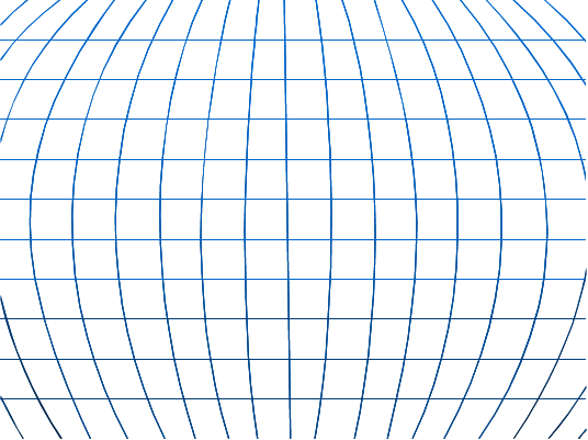
| Navigational map-interface: |
|
| The last search interface we
want to discuss is the navigational map interface. We’ve mentioned earlier
that most resources such as aerial photographs, images, maps, historical
text, etc. have geographical attributes. It was realized that instead of relying
upon the traditional keyword search and hierarchical classification scheme
for access to these resources, a novel and more effective approach would be
to make use of a map-based interface. (show) By looking at the figure, you
can have an idea on what we mean by navigational map interface. This picture
is taken from the webpage of the Alexandria Digital Library (ADL). ADL’s
collection focuses on information supporting Earth and Social Sciences, which
includes resources such as aerial photographs, world maps, etc. In ADL, the
main search interface will be this map browser. The primary function of this
map browser is to let the user define spatial regions as one of the feature
to search for resources. For example, in this figure, we’ve selected USA, which
means we would only like to obtain resources which have some connection to
America. Notice the square grids in the figure. This map browser allows us to
go deeper inside the map, so that we can define a more specific geographic
region. |
|